Tuesday, October 28, 2014

9 Tips for Trekkers Dreaming of the Himalaya


Very useful information for trekkers heading to the Himalaya from a seasoned "pro" and expedition leader Adrian Ballinger- read about it in the link below:

9 Tips for Trekkers Dreaming of the Himalaya

Tuesday, October 21, 2014

Rene Burri Magnum photographer passes away


Legendary Swiss photographer Rene Burri passed away in Zurich yesterday. He was 81. Burri is best known for his photographs of famous famous personalities like Picasso, Richard Nixon, Winston Churchill etc.

 For some of Burri's great work do visit  http://www.magnumphotos.com/C.aspx? P3=CMS3&VF=MAGO31_10_VForm&ERID=24KL5350UE   

He will be sorely missed by all photographers and his fans worldwide.


Saturday, October 18, 2014

The Annapurna Foothills Trek: December 21-28 2014


South Col Expeditions will be running the Annapurna Foothills Trek over the Christmas vacation for the fourth year in a row. This trek is extremely popular with families, children and those who want to get a feel of trekking without being in the mountains for a long period. There ares still some seats available so email me at sujoyrdas@gmail.com to sign up!

For testimonials from other South Col trekkers please do visit www.southcol.com/testimonials

The Annapurna foothills provide tremendous trekking with delightful trails connecting villages and ridge tops. This picturesque trek winds through enchanting villages with ochre thatched houses, terraced rice fields and rhododendron forests, which are spectacular in the spring when whole hillsides are cloaked in colourful flowers. The ridge top village of Ghandrung provides one of the finest viewpoints of the Annapurna Mountains with magnificent views of the four Annapurnas, and Machapuchare with its fishtail summit. It is a  good walk to the top of Poon Hill 3150 metres with a dress circle view over the Annapurnas and Dhaulagiri as well. 

Day 01   Kathmandu to Pokhara  by micro bus 6 hours night at Pokhara. 

Day 02  Pokhara to Kande to Austrian Camp to LandrungWe  leave in the morning after a splendid sunrise over the entire Annapurna range and drive to Kande. From Kande we climb to Austrian camp in around two hours and then walk to Pothana in half an hour. From Pothana the trail climbs uphill to Deorali from where it makes a steep descent to Bichok. From Bichok it is a level walk to Tolka where we break from lunch. From Tolka it is an hours walk to Landrung our night stop. 


Day 03 Trek to Ghandrung  (1950 metres) 5-6 hours walking The large village of Ghandrung can be seen directly across the valley from Landrung. This is a short walking day allowing time to explore Landrung and Ghandrung. From Landrung we descend to the Modi Khola River and cross on a large suspension bridge. The ascent through terraced fields to the picturesque town takes around 2 hours. Ghandrung is largely a Gurung town and is the headquarters of the Annapurna Conservation Area Project (ACAP). Many of the lodges here have the more environmentally friendly features that ACAP encourages such as back boilers, solar panels, etc.  The views of the Annapurna Mountains and Machapuchare from here are stunning.

 Day 04 Trek to Tadapani (2595 metres) 4 hours walking From Ghandrung the trail climbs gently to the village of Baisi Kharka where we stop for a cup of tea and then make the final ascent to Tadapani. Overnight at a lodge in Tadapani. Theviews of the Annapurna Mountains and Machapuchare from here are stunningly close.  

Day 05 Trek to Ghorepani  (2750 metres) 6-7 hours walking The trek from Tadapani to Ghorepani involves a number of ups and downs! We pass through the villages of Banthanti and Deorali before reaching Ghorepani. Overnight at a lodge at Ghorepani.  

 Day 06  Ghorepani to Tirekedhunga  (1515m) -5 hours walking We visit Poon Hill at sunrise to watch the views over Annapurna and Dhaulagiri. After breakfast we begin our walk down to Ulleri (1960m)  We stop for lunch at Ulleri and then start descending the 3000 steps to Tirkedhunga ( take it easy!). Night at Tirkedhunga. 

Day 07 – Tirekedhunga to Birethanti to Pokhara (885 metres) 4 hours walking The trail descends from Tirkedhunga to the village of  Birethanti. We have our lunch at Birethanti and then walk for half an hour to Nayapul. We cross the Modi Khola on a suspension bridge then follow the river valley to the road-head at Nayapul. Here our trek ends and our private vehicle takes us the short way to Pokhara. Here we check-in at the Gurkha Haven Guest House again  From the hotel roof, across the lake and above the terraced hillsides, we may catch a glimpse of the sun setting on Annapurna and Machapuchare once again. 
Day 8: Pokhara to Kathmandu and flight to onward destinations


Friday, October 10, 2014

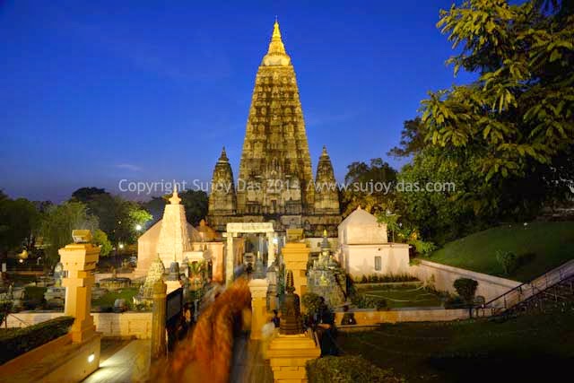
Mahabodhi Temple: Bodh Gaya

A forty minute drive  from the town of Gaya, Bodh Gaya boasts of a number of good hotels and guest houses. There is also an international airport at Gaya with links to Myanmar, Thailand and Sri Lanka.

The Mahabodhi Temple in Bodh Gaya  is a UNESCO  World Heritage Site, where Lord Buddha attained enlightenment.  The original temple was completed in the 7th century AD in the reign of the Gupta kings.To  the west of the main temple is the famous Bodhi tree where Buddha meditated.

The temple complex has a number of attractions like the Ratanaghara, Vajrasana, the Rajayatna tree, Meditation Park, Muchalinda Sarovar etc which are worth visiting.

These are some photographs from the Mahabodhi Temple:

The temple complex at dusk


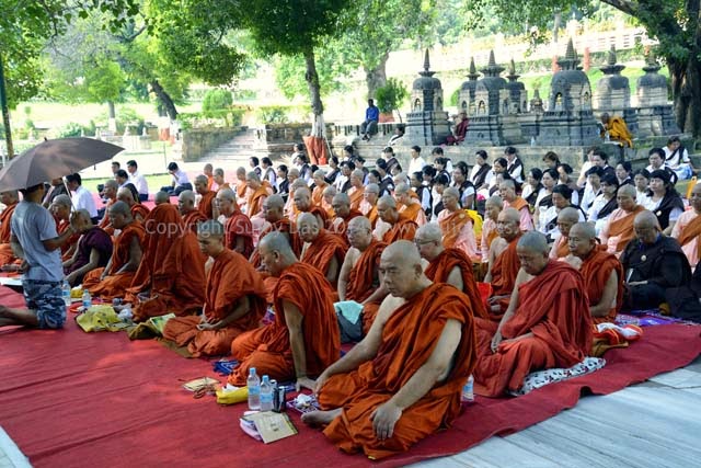
Monks pray under the Bodhi tree

The Cloister walk within the temple

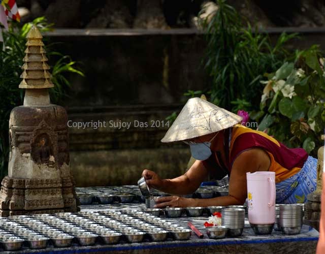
Preparing butter lamps

The butter lamp room within the temple

Thursday, October 2, 2014

Chamser Kangri, Mentok Kangri and Lungser Kangri

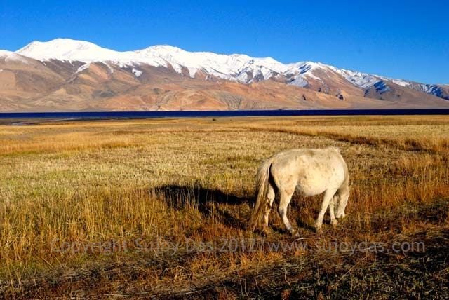
Tso Moriri
The area around the lake of Tso Moriri in Ladakh has a number of peaks crossing that magical height of 6000 metres and the three "Kangri's" listed below are without doubt the most popular.

In the season which is June to August there are a number of small groups who make attempts on these peaks often after a trek from Rumtse to Tso Moriri which is the perfect aid to acclimatisation.

So if you are looking to climb a peak in Ladakh and want to avoid the crowds of Stok Kangri then one of these may be ideal for you!

Chamser Kangri
The highest peak of the Chamser group is 6620 metres and the climb requires a base camp around 5000 metres which is a day's walk from Korzok village. Camp I is set up on a large plateau around 5700 metres and then Camp II around 6150 metres  from where the summit is reached in a day's hard push. However, this summer the Indian Army refused permission for Chamser Kangri due to security reasons and so many teams looked for alternatives in the region

There are three peaks in the Chamser group all of varying levels of difficulty. I exchanged some notes with Kuntal Joisher, who is presently on his way to climb a 8000 metre peak in Nepal, Manaslu.

This is what Kuntal says "Regarding Chamser, it's a beautiful mountain, with a super scenic approach trek to the base camp. I climbed Chamser right after I finished Rupshu trek and then Mentok. We completed the climb in 3 days and I was literally able to run up the mountain. The route from BC to summit is fairly steep and it's mostly a snow walk. There is no ice, or glacier, and in my case no crampons were required. It seems that this year every group that applied for Chamser climbing permit got rejected due to security concerns. The other beauty of Chamser is that it has 3 summits, Chamser 1 (which is the main summit), Chamser 2 (which is quite a difficult summit, and a technical one too), and then Chamser 3. Chamser 3 is a little over 6000 meters and offers a simple gradual trek to the summit. So if there is someone in your group with less experience, they can choose to go up Chamser 3. "


Lungser Kangri
The highest peak of the trio at 6665 metres, Lungser Kangri also shares the same Base Camp as Chamser Kangri on the grassy meadow called Kurchya around 5000 metres. There is a Camp I at 6100 metres on an open plateau and then Camp II at 6250 metres near a small lake. The last push on the summit ridge can be very tiring.

Mentok Kangri
Mentok Kangri lies south of the village of Korzok and the highest peak of the range is at 6250 metres.

Kuntal Joisher who has climbed Mentok comments:

"Mentok has multiple peaks (1,2,3) and each peak offers multiple routes up the summit. The route we chose up Mentok was a fairly technical one, and so our Sherpas went ahead and fixed lines. We then ascended the fixed lines on a fairly steep gradient ice wall. This involved quite a bit of cramponing and jumaring. We then accessed the summit ridge, which was quite exposed, narrow and rocky. Now, we could have taken a completely non ice/snow/rock route. This route is up a scree gully. So even though the route may sound easier, it's a horrendous route with constant rockfall.. In the end I ascended up the ice wall and rocky ridge, and descended down the scree gully, as I wanted a full traverse experience. Rest of the team descended the same way they went up."


Some Useful Links
Chamser Kangri by Micah Hansen
http://www.indietrekking.com/himalayan-trekking-guide/ladakh/chamser-kangri-chhamser-kangri

Chamser & Lungser Kangri
http://randomadventurez.blogspot.in/2012/09/chumser-lungser-days-1-to-8-on-chumser.html

Mentok Kangri by White Magic Adventure
http://www.whitemagicadventure.com/details/mentok-kangri-i-6250m.html

LinkWithin

Related Posts Plugin for WordPress, Blogger...