Thursday, December 24, 2015

Peakfinder: The Nar Phu Trek in Nepal

View of the Annapurnas descending from the Kang La pass
I had written earlier in my blog about the Peakfinder app which downloaded onto a phone allows you to identify the mountains from a database which you need to download. You dont need to be connected to the internet to use this app.

This year in October I used the Peakfinder app quite extensively on a South Col Trek to the Nar Phu valleys of Nepal and across the Kang la pass. The screenshots below give the names of the peaks as well as the location and altitude. I plan to do this from now on for all the treks we do so that a good database is available for future trekkers.

For my blog posts on Nar Phu do visit
http://www.sujoyrdas.blogspot.com/2015/12/the-nar-phu-valleys-of-nepal-i.html
and
http://www.sujoyrdas.blogspot.com/2015/12/the-nar-phu-valleys-of-nepal-ii.html


On the descent from Kangla pass - more peaks come into view

From near an emerald lake 30 min below Kangla pass

Approaching Nar village

Kangla Pass

From Kangla Phedi below the pass

From Koto Qupar - the start of the trek

From Kyang 

From Meta on the second day

From Nar Village

Near Besisahar

From Ngawal on the Annapurna circuit

Wednesday, December 16, 2015

The Nar Phu Valleys of Nepal - II


In October 2015, South Col Expeditions trekked to the valleys of Nar and Phu bordering Tibet in remote Nepal. The first part of the route and day wise schedule is here
http://www.sujoyrdas.blogspot.in/2015/12/the-nar-phu-valleys-of-nepal-i.html
This is the second and concluding part.

October 5 2015
Phu to Nar Phedi
The morning was cloudy once again and we left at 7 10 am. The lodge was very expensive charging around Rs 750 for a dal Bhat possibly one of the highest in Nepal. We retraced our steps down the valley and this time took the lower route back across the river. We made good time and got into Kyang by 9 50 am.


After a brief stop we set off for Chyakhu and got there by 11 05 am. Chyakhu was busy as some European groups had stopped there for lunch. We saw some yaks fighting in the meadows near the tea house. For non camping groups Chyakhu is a good option after Meta as there is a small house with two rooms which can be used for the night next to the tea shop. From Chyakhu we continued down the valley in beautiful autumn light and got to the trail junction of Nar at around 1 35 pm. From the junction there is a steep downhill over a very stony path - it was also extremely dusty and windy and blew my cap and pack cover off. The bridge was reached in about 25 minutes and then there is another uphill climb to the monastery which takes around 20 minutes. The monastery is brand new and the rooms are also excellent the best we have had on this trek so far!


Phu Village
Phu to Kyang 2 hrs 30 min to 3 hrs; Kyang to Chyakhu 1 hr to 1 hr 15 min; Chyakhu to Nar trail junction 1 hr 30 min to 1 hr 45 min; Nar trail junction to bridge 20 min to 25 min; bridge to monastery 20 min to 30 min.

October 6 2015
Nar Phedi to Nar village.


Doorway Nar Phedi Monastery
We left from Nar Phedi monastery around 8 10 am. Ajmal had decided to go down to Koto Qupar as he was not feeling very well and we gave Sushil one of the porters with him. I was sorry to see him go but I realised that it was the best decision for him and he was not really enjoying the uphill climbs due to his poor health. Our climb was relentless for the first one hour and we reached a small pass. From here the climb continued uphill and in about forty minutes reached another high point which showed up as 3995 metres on my altimeter . From here there was a very fine view of Kangaru and Pisang peak was in front of us for most of the way.  The trail then levelled off for some time and passed right below Pisang before climbing up to another small pass. The trail then eased off and was passed through a gate which had probably been erected to keep the yak and sheep within their pens. Within 15 minutes of passing through this gate, the path reached a level plateau with ten magnificent chortens against a backdrop of the snow peaks and the barren cliffs. 


Chortens before Nar Village with Kangaru Himal
It was truly a magnificent sight and the artists who had built them so many years ago on this windswept exposed plateau must have been truly great men! From here  a short ten minute walk brings you to the entrance of Nar village.

Nar Phedi to 1st pass 1 hr; 1st pass to 2nd pass 30 min; 2nd pass to plateau with chortens 1 hr 15 min; chortens to Nar village 15 to 30 min. Total time would be between 3 to 3.5 hours.

Travels in Nar village
We stayed at the Shanti lodge which is one of the older lodges in the village. The owner Shanti Galay was extremely helpful and friendly.  I knew that sometime in the 1980s King Birendra had given permission to a photographer Nick Wheeler to document the villagers of Nar and Phu. The book they brought out was called Cloud Dwellers of the Himalaya now sadly out of print. In 2006 Wanda Viequex had visited Nar and Phu with a copy of the book and had managed to show the photographs to many of the villagers who were able to identify themselves so many years ago. In particular she visited the home of "cover" girl Pema Bhutti who was possibly in her seventies at that time.  I was  interested to find out if she was still alive nine years later  in 2015 and also visit her house. Shanti directed us to her house in the village. It was the harvesting season. All the fields had been harvested of barley and on every roof top of every home threshing and winnowing of the grain was taking place. Whole families were busy with this all day and it presented a spectacular sight.  We found the house and found Pema Bhutti's daughter and husband with their grandchildren.  We learnt that Pema had passed away in 2008 after suffering from cancer. They knew about the book but did not have any copy with them . They also confirmed that none of the villagers in Nar would have a copy. 


 Pema 's daughter Pemba Chenzom and husband Mingmar Copel Gurung gave my guide Shyam and me tea in their kitchen. They wondered if it was possible to get some sponsorship for their grandchildren to go to school in Kathmandu.  
From here we continued to walk through the village photographing the houses, harvesting, the village folk which was extremely interesting. Below in the fields of Nar we saw most of the cattle were grazing including yaks, horses and sheep. It was a beautiful sunny day with the peaks above the valley, the pleasant autumn sunshine, the harvesting in full force and the roof tops of the three monasteries glinting in the mellow evening sunshine. At around 4 pm I decided to walk back around 20 minutes the plateau with the ten chortens. The evening sunlight had illuminated them beautifully backed by the peaks of Chombu and Kangaru. We were also able to see Pisang peak above us and Chulu East a popular trekking peak on the Annapurna circuit. Shyam and I sat  on the grass for some time and savoured this idyllic surrounding. Nar is a village where I could happily stay a few days interacting with the village folk and photographing their life and fast vanishing culture.


Harvesting Nar Village
October 7 2015
Nar to Kangla Phedi
The morning dawned clear but I was greeted with the news that one of our group Ashutosh was not feeling well- he had been suffering from a throat infection right through the trek and was now quite breathless. He took the decision sadly to descend to Koto Qupar by making a night stop at Meta. We were sad to see him go but realised in his present condition crossing the pass would be both difficult and risky. After breakfast I went down with Shyam to see the old Samten  Pelgye Ling monastery which had some remarkable old statues. 


Interior Samten Ling monastery
A nun from Kathmandu showed us around - interestingly she had been to India! We had an early lunch and left Nar at around 12 noon. We left through the exit gate of the village and started a climb out of the valley. After about half an hour the gradient eased a bit and we found ourselves in a broad valley with Pisang Peak and it razor sharp ridges on the left. The trail continued to climb gently through yak pastures and high above we spotted two herds of blue sheep , one of them quite large around thirty animals high above the  valley floor. The path then went around the hill and from the viewpoint before going down we saw Kangguru, the summit of Manaslu, Ngadi Chuli and much closer the top of Pisang Peak. We soon reached a small campsite with a broken down stone shelter which is the Kangla Phedi Base camp. The beginning of the trail to the pass could be seen clearly over moraine and scree slopes.  Just behind our camp to the east was a small snowy peak which could not be identified. We planned to start at 5 am tomorrow so as to cross the pass between 8 and 9 am and hopefully get the wonderful view of the northern sweep of the Annapurnas.


Night sky and the Milky way at Nar Phedi
Nar to Kangla Phedi 2 hrs to 2 hrs 30 min

October 8 2015
Kangla Phedi to Kangla pass to Ngawal
The night was very cold in the tent, especially my toes which I could not warm up despite the best of efforts. I got up around 3 45 am and started the laborious job of packing up the sleeping bag and then my rucksack. After this I stepped out at around 4 15 am and began to dismantle my tent . Using gloves and a headlamp it was tough going and the minus 8 Celsius temperature did not help matters very much. The fly sheet was frozen and I had to pack it up with the ice hoping to dry it out in the sun in Ngawal this afternoon. The kerosene stove was purring in the kitchen shed and we all had hot coffee and muesli with milk. We finally got away around 5 35 am.  The trail initially left the campsite and started a slow climb upwards to a small bridge in around 20 minutes. From the bridge the path climbed relentlessly through a series of switch backs  until it reached a small chorten in about an hour and a half. From this high point looking east we could see over the valley the peaks of Chombu, Kanguru, Manaslu, Ngadi Chuli , Himal Chuli and the sheer cliffs of Pisang peak. To help in the snow trail markers in orange and blue had been positioned at regular intervals , a welcome feature. This morning was perfect as there was not a cloud in sight and no wind or snow. The trail continued past a few false summits until it reached an emerald green glaciated lake at 5200 metres in about 2 hrs 45 min from Kangla Phedi. The pass was visible from the lake another 30 min away. We eventually got to the top around 8 50 am to be rewarded with a spectacular view of the entire northern sweep of the Annapurnas including Lamjung Himal and in the far right corner Dhaulagiri. Below us we could see quite clearly the new road which was now being used by jeeps and buses connecting MaƱang to Besisahar . The airstrip of  Hongde was also visible and to the west of that was the village of Ngawal our destination  for the day.


View from Kang La
We left the pass around 9 30 am and headed down one of the steepest scree slopes which I have encountered. For an hour we had to gingerly make our way down testing each steep and using our trekking poles for support. I wondered how difficult this descent would be in snowy conditions. After an hour and a half we reached the grassy slopes and began to descend on a well trodden path towards the valley. From the pass to Ngawal was a drop of around 1700 metres in around 3 to 4 hours which is a knee crunching descent and we were all feeling it towards the end. In around 2 hrs and 30 min we could see the village of Ngawal below us but it was still an hour away. Finally around 1 15 pm we entered Ngawal having walked for around 8 hours without any meals or major stops. The pleasures of the Annapurna circuit like a hot shower, good meals and comfortable beds awaited us!


Lake on the trail to Pisang
Kangla Phedi to 1st chorten 1hr 30 min; 1st chorten to emerald lake 1 hr 15 min; emerald lake to Kangla pass 30 min. Total time from Kangla Phedi to the pass would be between 3 to 4 hours depending on walking speeds and stops.
Kangla pass to Ngawal 3 hrs 30 minutes to 4 hours.

Wednesday, December 9, 2015

The Nar Phu Valleys of Nepal - I

Our team on top of Kangla pass (5320m)
South Col Expeditions trekked the Nar and Phu valleys of Nepal in Sept-Oct 2015. In this two part post the route and terrain is described for future trekkers to this region.

Click on map to see larger image
September 30th 2015
We left Kathmandu at around 8 am for Besisahar. Lok was lucky to arrange a micro bus for us as he had managed to get some diesel given the present difficult situation in Nepal. Due to the fuel shortage the roads were reasonably empty and we made good time getting into Besisahar by 1 . 15 pm. There was a huge traffic jam at the entrance of the town and by the time we reached the jeep stand it was 2.30 pm. There was a premium for the jeep to Koto Qupar- what would normally cost Rs 20,000 was quoted at Rs 33,000 citing the fuel shortage as an excuse. We left Besisahar at  3 pm and headed up the Marsyandi. I was quite shocked to see the devastation near Bhulbhule. With Chinese aid a new Hydel project and dam was being constructed.  Large chunks of the hillside had been decimated to make room for concrete buildings. Debris from the ash mud and stone chips had pullout end the Marsyandi changing its colour from jade green to ash grey. The narrow trail masquerading for a road was full of boulders and fast flowing streams rushing across. The circuit had changed beyond recognition. No wonder very few trekkers walk the route right now. We reached Syange at around 5 30 pm and decided to call it a day. The Waterfall lodge was very scenically situated right on top of the roaring Marsyandi. Tomorrow we would get to Koto Qupar.


The Waterfall Guest House 

October 1 2015
We left Syange at 8 am. The rough trail continued and we reached Jagat in around 30 min. The jeep was only able to do between 6 and 8 km per hour due the terrible condition of the road. We reached Dharapani at around 10 45 am and stopped to show our ACAP permits at the check post. We saw the trail coming down from bimthang and the Manaslu circuit towards the east. We left Dharapani after a cup of tea and headed up the Marsyandi and eventually got down from the jeep at 12 20 pm about half an hour from Koto Qupar and walked the remaining distance. The valley had now opened up and we saw Annapurna  2 in front of us and Manaslu to the east. We stayed at Hotel Himlung in Koto and we had the lodge to ourselves. Krishnan and I walked upto the next village Chame  in about 30 min on an acclimatisation walk and came back in around an hour.  I cleared the permits at the check post so that next morning we could leave without delay. No further news on the fuel crisis hope it would get settled very soon. We passes around 25 Trekkers most of whom were doing the Annapurna circuit a far cry from the number of trekkers who used to do this route earlier.


Annapurna II near Koto Qupar

October 2, 2015
Koto Qupar to Meta
We left Koto at 6 45am - a record for South Col as far as early starts are concerned. We immediately descended to a suspension bridge which we crossed and starting walking on a well maintained trail which hugged the river. After about an hour and 45 minutes we reached another suspension bridge which we crossed and started walking up the right bank of the river. In about an hour from the bridge we reached a small house with an ACAP sign board for Naar Phu. Ten minutes away was another small house where our group had stopped for an early lunch as there were no more tea shops on the way. We had a one hour lunch break and then started for Dharamsala. Five minutes away was a third house where a German team were having their lunch. The trail continued to wind its way up the gorge and fifty minutes away we reached another suspension bridge which took us back to the left bank of the river. Soon after we came to a small cave marked Odar which can double up as a camping spot in an emergency. The trail then went down and within a few minutes another suspension bridge appeared with a sign to the right pointing to a hot spring. We took the left trail and finally got to Dharamsala at 1 20 pm. We found a new shelter had been constructed at Dharamsala but there was no tea shop for meals.

Waterfall across the trail near Dharamsala

We stopped for ten minutes and then started the climb to Meta at 1 30pm. The first thirty minutes followed the river climbing up and down but then started a steep 50 minute push up the hill on a steep gradient which took us to a pass on top of the hill. From the pass Meta was 10 minutes and we reached at 3 15 pm ending a long day. I was surprised to find at least four to five lodges in Meta 3600 metres with at least forty beds. If you can make the push from Dharamsala  I recommend staying at Meta so you save a night of camping. I found that the Nepal telecom Namaste network working in Meta but the signal was weak.


Koto Qupar to 2nd suspension bridge 1 hr 45 min; 2nd suspension bridge to 1st House with ACAP sign Nar Phu 1 hr; 1st house to 3rd suspension bridge 50 min; 3rd suspension bridge to Dharamsala 1 hr 30 min; Dharamsala to Meta 1 hr 45 min to 2 hrs. 


October 3 2015
Meta to Kyang
We left Meta at 8 10 am. In the morning I used my peak finder app and found that the big peak from Meta to the south was Lamjung Himal and not Annapurna I I as claimed by the locals. The path out of Meta was well defined and it was not necessary to cross any moraines as mentioned in the Lonely Planet guide! In 30 minutes we reached a junction with the trail ahead going to Phu and the sharp left trail heading to Nar. The junction is marked. Below us all along this section of the walk we saw the new monastery of Nar Phedi perched on a ledge below the long climb to Nar. The trail continued following the river valley making gentle ups and downs until it reached a clearing with some abandoned stone shelters which was called Jhunum about one hour 50 min from Meta. From Jhunum we crossed a suspension bridge over the river and made a climb to reach Chyakhu in 50 min. 


View from the trail before Junam

There is a small tea shop in Chyakhu where food is available and it is also possible to stay. It is very expensive dal Bhat was Rs 650! The place is surrounded with abandoned Khampa ruins and the icefall of Kangaru peak and the peak can be seen from this section of the trail. From here the trail climbs up to a pass and then drops down across another suspension bridge to start climbing again. From here the plains of Kyang are visible about 10 min below. There is a small hut in Kyang but no food is available. We camped at Kyang as we had tents making the next day to Phu much shorter. Water is available close to the hut and there are also a large number of abandoned Khampa settlements here.


Meta to 1st trail junction 30 min; 1st trail junction to Jhunum 1 hr 20 min; Jhunum to Chyakhu 50 min to 1 hr; Chyakhu to Kyang 1 hr 15 min to 1 hr 30 min.
October 4
Kyang to Phu
The night was cloudy in Kyang and I came out of my tent at around 8 pm- managed some shots of the stars until the clouds closed in again. The morning was also cloudy with low lying clouds on the adjacent ridges. We saw that Pisang Peak had a fresh dusting of snowfall. We left Kyang at around 7 30 am and in 30 minutes reached a bridge over the river. Do not cross the bridge but carry on along the right bank. The narrow trail continued to hug the river as the gorge became narrower. In an hour and ten minutes you reach a new house which is lying vacant- it could be intended as a future tea shop. The trail soon comes to a second bridge - there is a path of the other side which also leads to Phu. We continued along the right bank without crossing the bridge and the trail soon climbed high above the river. The rock faces had now begun to resemble Mustang and at a point around three hours from Kyang the canyon narrows and the river flows through some spectacular looking rock spires. The trail then climbs steeply for around 15 min to reach the Phupi Gyalgu gate - the entrance of Phu. The trail then crosses a ruined Dzong and then some chorten said painted in Mustang like colours and blue painted mani stones. Finally it crosses a suspension bridge and reaches Phu village ( 4060m).


Phu village
 It was the harvesting season in Phu and every house was threshing paddy in the open courtyards outside. We visited the spectacular Tashi Lhakhang Gompa at 4150 m above the village but sadly it was locked and we could not get in. The peak of Kanggaru could be seen opposite the village which is but a mere extension of Mustang.

Kyang to 1st bridge 30 min; 1st bridge to new house 40 min; new house to bottom of climb to the Phu gate 1 hr 10 min; Phu gate to Phu village 30 to 40 min

Tuesday, December 1, 2015

Everest Trek- Updates November 2015


I spent seventeen days in the Everest region in November 2015 and here are some updates from the area:

In addition to Tara Air, Sita Air and Simrik Air, Goma Air is flying to Lukla with two Czech planes every day. The planes are new and that makes a big difference from the old Twin Otter Aircrafts.


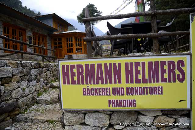
 There is a Herman Helmers branch now operating in Phakding just after you cross the suspension bridge on the way  to Benkar and Monjo. It has all the apple pies, doughnuts, premium coffee and breads that are available in Namche! The prices are the same.


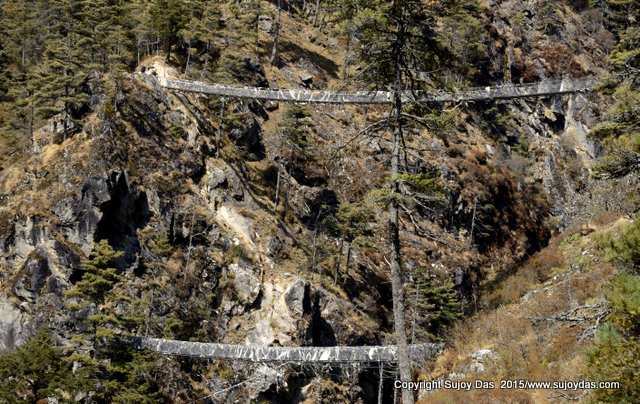
The last suspension bridge below Namche has been replaced by a new bridge which is about 50 feet higher so there are presently two suspension bridges over the river the lower one not being in use.


The bridge over the Imja Khola below Devoche and on the way to Pangboche has collapsed in the earthquake and a new bridge has been built further down on the east bank of the Imja river.


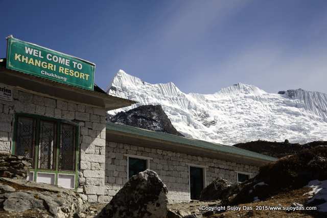
The Chukung Resort in Chukung has been totally renovated and there is also a new swanky Khangri Resort with plenty of rooms. The popularity of the Island Peak climb has possibly been the reason for the  lodge boom in Chukung.


There is a new lodge in Lobuche with 35 rooms located right next to the Eco Lodge. The lodge is called Oxygen  and was open for just a month when I visited on November 14th 2015. The young and energetic owner who also works at the Pyramid research station is trying to attract trekkers and given the number of clean bathrooms he should get good business for the next season. However the dining hall was like an ice box as the heating was not working too well. He hopes to fix this for the coming year.


There are five  lodges in Dzongla now as well as a number of permanent tents so accommodation in the peak autumn season should not pose a problem. The new lodge which we stayed in was Mountain Home.


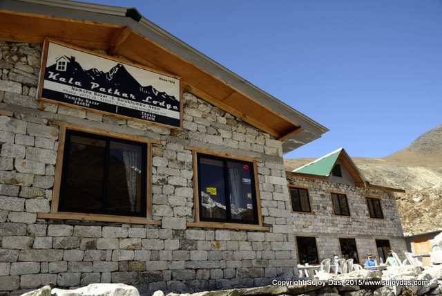
In addition to the old and trusted Yak Lodge at Dugla, we now have the new and swanky Kala Pattar lodge. So with two good lodges accommodation should not be an issue in Dugla any more.


Some of the lodges in the Khumbu have a wifi internet  card , Everest Link which allows you to use wifi. It is a prepaid card with an expiry in terms of time or capacity whichever is earlier. However I found that the card only worked in the lodge which had sold it, possibly linked in some way to the router which the lodge was using.


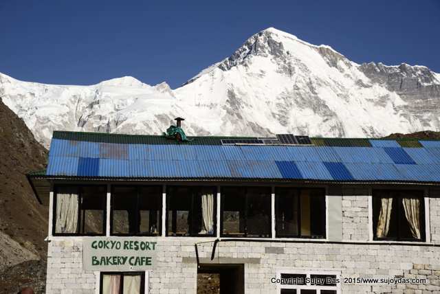
The Gokyo Resort which was earlier being run by S D Sharma has now being leased by Maya Sherpa who runs the ever efficient Hotel Namche at Namche Bazar. The lodge is being run by Maya,s brother Nima and is back to the same levels of friendly and efficient service.


South Col Expeditions runs treks to the Everest region every year. For more information do visit www.southcol.com

LinkWithin

Related Posts Plugin for WordPress, Blogger...