Sunday, May 29, 2016

Everest | May 29th 1953

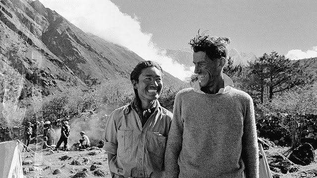
Tenzing and Hillary after the successful climb at Thyangboche monastery
Today is sixty three years since the first ascent of Everest.

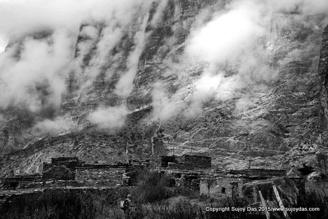
On 29th May 1953 at 11.30 am, a Sherpa and a New Zealander became the first men to stand on top of the highest peak on this planet.  However the intervening years has seen a sea change as far as Everest is concerned. The mountain, enshrined in controversy, has now become a playground for guided expeditions, with clients paying between  twenty five to sixty thousand dollars or more to stand on the highest point on earth. The South Col route climbed in 1953 is now disdainfully referred to as the “yak trail”. The dangerous icefall below the Western Cwm is maintained by a team of sherpas right through the season led by a senior “Icefall Doctor.” In order to make it possible for inexperienced clients to summit Everest, the entire mountain has fixed rope from bottom to top. This year 2016 the first ascent of the mountain was made by a team of nine sherpas from different expeditions who fixed  the rope right to the summit.

2014 and 2015 were both a  "lost season" for Everest due to the great Nepal earthquake which caused an enormous avalanche at Everest Base Camp on 25th April 2015.  In 2014 the loss of sixteen sherpas in the Everest icefall effectively ended the Everest season from the south side.

However, this post recounts through photographs,  the 1953 climb, the historic ascent of the first two men to summit Everest and the team of climbers and sherpas who supported them through this endeavour.

Tenzing and Hillary at Advance Base after the successful climb

Charles Evans and Tom Bourdillon at the South Col after coming back from the South Summit on 26th May 1953, a decision which Bourdillon regretted for the rest of his life

Returning from the South Col: Evans, Hillay, Tenzing, Bourdillon and George Band

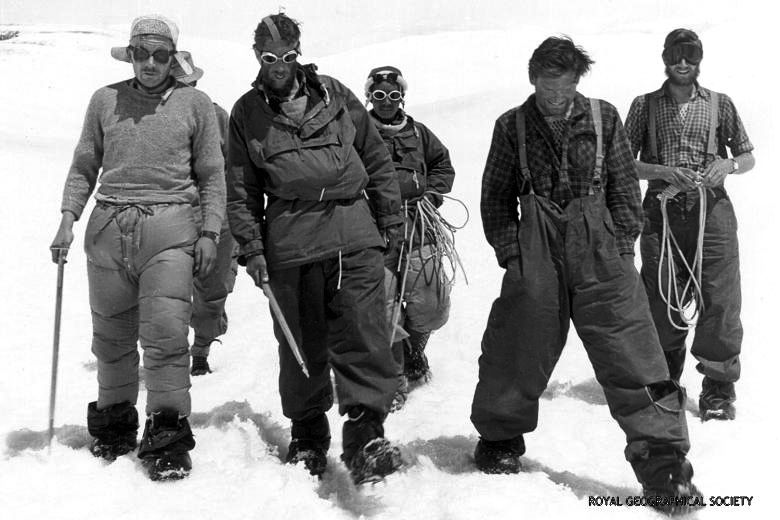
From left: John Hunt, Hillary, Tenzing and Ang Nyima. Standing : Alfred Gregory and George Lowe at Advanced Base after the return of Tenzing and Hillary from the summit

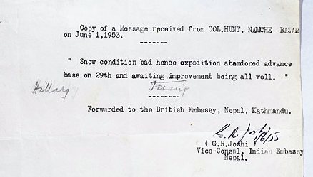
Telegram sent by Hunt in code which meant "Hillary and Tenzing reached summit on May 29th"

The team of climbers and sherpas at Base  Camp after the successful climb


Monday, May 23, 2016

Ghandrung - Ghorepani - Poon Hill Trek | Peakfinder Screen shots


The five day Annapurna foothills trek by South Col  happens every year in December and is extremely popular. It has some of the best views, excellent lodges, good meals and is only for five days.

Here are some of the Peakfinder screen shots of the views along the trek.

Austrian camp above Kande looking north east


Austrian Camp above Kande looking east


Tolka View


Ghandrung


Tadapani looking north east


Poon Hill looking north west

Poon Hill looking north and east

Pokhara View
To join our trek in December 2016 please do visit http://www.southcol.com/treks-nepal/trekking-annapurna/

Monday, May 16, 2016

Nepal Himalaya | A Journey Through Time


Nepal Himalaya: A Journey Through Time is being published by Bidur Dangol of Vajra Books, Kathmandu. The photographs for this book have been shot by me while the text is by Lisa Choegyal. There is a short foreword by Reinhold Messner.  There are eleven line drawings by Paula Sengupta

The book should be on the shelves and on Amazon and other web sites by end of June 2016.

Here are some photographs  shot in Archana Press, New Delhi where the book is being printed. It gives you an idea of what to expect!


Sunday, May 8, 2016

Markha Valley | Hindu Business Line Blink April 30th 2016

feature Image

The Markha Valley is one of the most popular treks in Ladakh. It is relatively short, located close to Leh, the walking is mostly below 4000 metres with  night stops around 3500 metres and has the best of Ladakh thrown in: Sculpted canyons and fantastic rock formations, medieval villages,  Buddhist gompas and snow-peaks. When approached from Chilling there is only one pass to cross the Kongamaru La which comes on Day 8 of the trek by which time most trekkers are properly acclimatised.  The photos below give a description of the trek which I wrote for Hindu Business Line Blink for the April 30th 2016 issue.

To read the article on line please visit http://www.thehindubusinessline.com/blink/cover/a-himalayan-trek-is-always-a-rewarding-escape-from-the-scorching-plains/article8532688.ece


To trek the Markha with us from July 15th to 24th 2016 do visit this link for all information  http://www.southcol.com/treks-nepal/the-markha-valley-trek/


Click on the photo to enlarge

Click on the photo to enlarge

Sunday, May 1, 2016

Nar and Phu | The Lost Valleys of Nepal

The trail to the village of Phu
"On the eastern side of the valley, sunlit pastures mounted towards the 23,000-foot summit of Kang Guru, a massive sugar-icing dome flawed by shadowy crevasses and ice-falls. Yaks grazed on the hill; the chiming of the bells they wore drifted down to us. To the west, our maps told us that the village of Nar stood on a shoulder of pasture land that ran up from the river, but the village was still hidden behind Pisang Peak. Northwards, the valley narrowed again between mauve and ochre precipices veined with glittering quartzite." 
Windsor Chortlton, The Cloud Dwellers of the Himalaya, The Bhotia

If you are walking on the famous Annapurna circuit in Nepal you will pass the small village of Koto Qupar. Right of the main trail there is a non descript track which plunges down into a forest and crosses a bridge over the  river. This is the trail to Nar and Phu villages, part of the restricted area of upper Nepal. A rewarding trek is to visit Nar and Phu villages and re- enter the Annapurna circuit at Ngawal crossing the 5320 metres Kangla Pass with it's dress circle view of the entire northern sweep of the Annapurnas.

South Col Expeditions trekked this route with a small team in late September-early October 2015. Here are some black and white photos from the trek.

A trekking team on the trail to Kyang from Phu from Kyang

Walking above Phu village with Kangaru peak in the background

Porters carry planks of wood for construction from Meta to Phu

The abandoned Khampa settlements at Kyang 

A yak descend on a rocky trail above Kang la Phedi

Village roof top at Nar

Main street of Nar village

Panorama from the Kang la pass 5320m
For more information and photos do visit http://www.sujoydas.com/Nepal-Himalaya/Nar-and-Phu-Valleys-of-Nepal/

LinkWithin

Related Posts Plugin for WordPress, Blogger...